This August Mike and I headed over to the Rockies to do some climbing. With a
solid year of training under our belts and fingers crossed for good weather we were hoping to get a chance to attempt a few routes from our tick-list over our week-long vacation.
Here is a recap of our trip:
Week 1:
Mike headed down to Invermere a week ahead of me to attend the
Alpine Club of Canada's North Face Summer Leadership Program. He learned a lot and had a fabulous time playing in the Stockdale Group Mountains with the Guides and fellow trip participants.
 |
| Base camp in the distance |
Week 2:
At the end of Mike's camp, I headed out to meet up with him in Banff.
Day 1: Travel Day
My trip started with a travel day from Vancouver to Banff. I had an uneventful day-long journey of flying to Calgary, hanging out at the Calgary airport, taking a bus to Banff and then hanging out on the main drag of Banff waiting for Mike to get into town. It was long day, but all went smoothly and I was happy to be in the Rockies and surrounded by mountains. The scenery and atmosphere of the mountain towns never ceases to amaze me, no matter how much time I spend there.
 |
| Hanging out at the Calgary Airport |
 |
| Passing thru Canmore |
 |
| Passing thru Canmore |
 |
| Waiting for Mike in Banff @ the Banff Ave. Brewing Co. |
Once Mike arrived in Banff, he picked me up and we went in search of a campsite. Turns out that not having camping reservation on a summer weekend in Banff is a bad idea. We ended up spending the night at the Two Jack overflow campground, i.e. a gravel parking lot slightly off the side of Highway 1. Oh well, it was somewhere to sort our gear and sleep for the night. At least the view was awesome!
 |
| Sorting gear |
 |
| Two Jack overflow camping |
 |
View from the campground
|
Day 2: Climbing Aftonroe
Aftonroe, 9-pitches 5.7 (with 5.8 variation), sport route on Guides Rock of Mt. Cory in the Bow Valley, Banff, AB. Approx. 4.5 hours car-to-car.
Click Here for Topo
We got up at 5am, packed up camp and hit up Tim Hortons in Banff for breakfast before driving to the base of Guides Rock off the Bow Valley Highway. The approach was quick and straight forward, about 30min up a well groomed trail, with some scree in the upper section to gain the base of the wall. It took us a few minutes to locate the route and gear up and we were off. We were happy to be the first party on the wall due to some loose rock on the belay ledges.
 |
| Approach |
 |
| View from the base of the route |
 |
| Ready to go, my lead! 2nd pitch |
The climb went fast and efficiently using Mike's newly learned transition techniques from his ACC course. It was a lot of fun swapping leads over the moderate bolted terrain. I was tasked with the crux pitch and pulled off the 5.8 bouldery start to the pitch instead of "making liberal use of the tree" as recommended in the guidebook to keep the route at 5.7. Do the 5.8 move, it's way more fun than stemming off of a little tree!
 |
| climbing some crazy slabs |
It took us just under 2 hours to top out and after a short snack break on the top we began the rappels. The 8 rappels back to the base took us about 1.5 hours with a bit of waiting and anchor shenanigans as there were about half a dozen parties now climbing the route below us and we had to share anchors with them to get down. Once at the base it took another 20min to hike back down to the car and we spent the afternoon setting up camp at the Tunnel Mountain Campground, doing laundry, grocery shopping and enjoying some celebratory ice cream for a successful first day of climbing.
 |
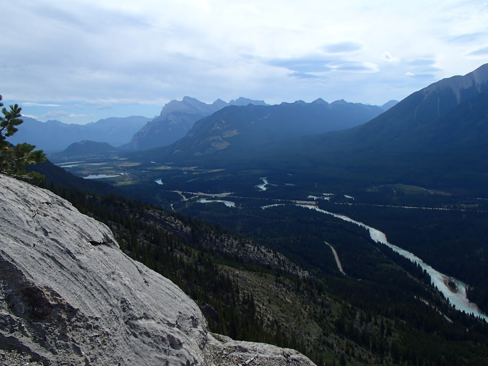
| View from the Top of Aftonroe |
 |
| Top of Aftonroe |
 |
| Top of Aftonroe |
Day 3 : Climbing Ha Ling
Ha Ling, NorthEast Face, 11-pitches 5.6, Canmore, AB. Approx. 9 hours car-to-car
Click Here for Topo
 |
| Ha Ling from the earth dam on the approach |
 |
| Approach |
On our second morning we had a 4:30am wake up call followed by another leisurely breakfast at Timmy's, but this time at the Canmore location, before making our way through the Town of Canmore and to the trail head in time for sunrise. Ha Ling is the obvious peak that towers over the Town of Canmore and has a popular hiking trail up the backside, like the Grouse Grind in Vancouver, minus the gondola.
 |
| View from the base of the route |
We geared up quickly and began the approach. The start of the approach was fairly obvious, walk across the earth dam and head up the trail on the far side. I was happy to see that the chain-link fence that the route description said we would have to climb had been removed as I wasn't super stoked about the idea of scaling fences at 6am with a full climbing pack on. We followed the trail easily through the trees but unfortunately lost it when we hit the scree slope. We had a bit of a thrash up the loose scree before we found the trail again and as a result the approach took about 1.5 hours when it should have been closer to an hour. Oh well. We made it to the base of the route and were still the first party there.
 |
| Base of the route |
 |
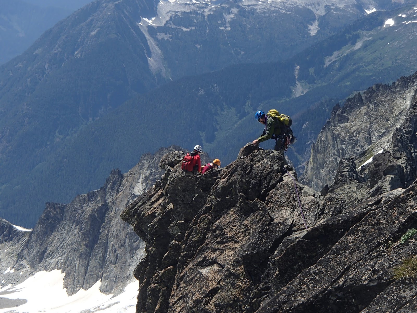
| 1st pitch |
The climbing on Ha Ling was bit more alpine-like than we were expecting. There was more loose rock around than anticipated for a classic route and reasonably long run outs; very much an alpine feel, not a casual day of cragging. The first two pitches have 25m run-outs, luckily they were 4th class, but you really would not want to fall! The route is trad with some bolts in key places and all the stations are bolted. Mike led the full route as I am still working on my trad climbing efficiency and we didn't really want to run out of daylight on the route.
 |
Mike updating his Facebook status mid-climb.
Just kidding; he's checking the digital topo. |
Overall it was good climb in a cool location; right above the Town of Canmore with great views of the Bow Valley. It had some fun features along the way, including a small roof to surmount and great crack features near the top and a lot of varied terrain. The climbing was a bit more in-your-face than we were expecting for a 5.6 and we were happy that we had waited until we had a bit more experience to get on it. I think it may have been more than we would have been up for if we had tried it back in 2010 when we first looked at the route.
 |
| Canmore |
The route took us about 6 hours to climb and the top-out was insane! We went from being alone on a wall all day (apart from the 3 parties climbing several pitches below us) to suddenly emerging onto a summit plateau and hiking trail packed with 50+ tourists.
 |
| Mike on the Summit |
 |
| Mandatory Hero Shot |
We became an instant tourist attraction on the summit of Ha Ling with all the hikers wanting know where we came from, how long it took, how hard it was to rock climb, etc. All I wanted to do was take off my climbing shoes and have a snack! We patiently answered a few questions and then excused ourselves for a well-earned rest and snack break before taking some summit photos and preparing for the hour-long hike back to the car.
 |
| Evil Chipmunk that tried to steal our summit chocolate! |
 |
| Good Advice! |
 |
| Back at the Car |
The overall trip took us about 9-hours car-to-car. The car was conveniently parked right beside a lake where we cooled off after an awesome day on the wall. We had been wanting to climb Ha Ling for years, so we were pretty happy to have finally had an opportunity to get on it. We ended our day by heading back to camp for dinner where we relaxed and enjoyed some celebratory beverages.
 |
| Ha Ling |
 |
| Ha Ling from Highway 1 (Right-hand Peak) |
To be continued......