Thursday, November 17, 2011

Viva Las Vegas!


Last weekend Mike and I, with our friends Ange and Kyle, headed down to Las Vegas for a whirlwind weekend of fun! we started our trip with a 7am flight out of Bellingham airport on Thursday morning to get the most of our day. We promptly checked into our room at Caesar's Palace (24th Floor with a view of the Strip!) and headed out to explore. We spent the day enjoying a Texas Hold'em poker tournament where Mike came in 4th place (one away from the Money!), we explored the strip and we indulged in a dinner buffet at the Mirage (mmm.....crab legs!)

The next day was our "lets act stupid" day to live it up, party and experience the craziness that is Steel Panther. We started our day with an early bird breakfast special on the Miracle Mile and then headed down to "slots-of-fun" Casino for an afternoon of $1 Blackjack and free beer. Ange and Kyle arrived that afternoon so we met up with them and spent the evening having a fabulous dinner and yummy blended drinks at Jimmy Buffet's Margaritaville. How can you go wrong having dinner at a place where a bikini-clad girl jumps out of a volcano, goes down a water slide and lands straight into a giant blender every hour?!?  After dinner we got decked out in our 80's attire and headed out to the House of Blues to rock out to Steel Panther. The show was absolutely ridiculous (as expected), but incredibly entertaining and well worth checking out. I'd see them again in a second and I was originally incredibly skeptical of going.

We decided we'd "class it up" a bit on the following day, so after a nice brunch we strolled along the strip and checked out all the fancy hotels. We wandered through the new City Center, Cosmopolitan and Aria hotels which are absolutely stunning. We also checked  out the craziness at MGM which was getting ready for fight night. That evening we all got dressed up and went for a nice dinner  at "Trevi" in the Forum shops of Caesar's Palace where we had a great bottle of wine and some extraordinary Ahi Tuna. After dinner we wandered down to the Bellagio to see Cirque du Soleil's "O", which was amazing and recommended to everyone! We finished off our night with some slots, poker tournaments and dollar margaritas at Gambling Bills Saloon.


Our last day on the strip was pretty laid back. We went to a tasty breakfast buffet at New York, New York and spent the afternoon at the Shark Reef Aquarium in Mandalay Bay where we got to pet some Sting Rays, which was pretty cool! After that we spent the rest of the day relaxing back at Caesar's Palace before making our journey home, ending an excellent fall getaway!

Thursday, October 27, 2011

Fall

Sammy and Uncle Mike at the Petting Zoo

Quality Time with the guys

Turkey Dinner at the Oliver's

Mosquito Creek

Hallow's Eve Trail Race


Tuesday, September 27, 2011

Rubble Creek Classic

Lara and I tackled the Rubble Creek Classic Trail Race on Sunday in Garibaldi Park, Whistler BC. Here's a  recap of our day on the trails:

First, some info about the race. The race is part of the Sea to Sky Trail Running Series and is put on by Escape Route, an outdoor store based in Whistler and Squamish. The race has been going since 1985 and is a "grass-roots" style run. There is no support, aid or trail markers, you must be 100% self-sufficient along the course. There is a sweep however, in case of emergencies. The course runs from Cheakamus Lake over the Helm Creek Trail to Garibaldi Lake in Garibaldi Park. Click here for Course Map by Trailhunger.com

Course Details

Distance:  24.5km
Elevation Gain:  1338.4m
Elevation Loss:  1592.8m
Highest Elevation: 1781.6m
Lowest Elevation: 557.4m


 We decided to do this race because neither of us had ever explored Garibaldi Park and a group of friends that we run with were also planning to try out the race. We'd heard glowing reviews about the amazing scenery along the course so thought we'd jump on the band wagon.  We didn't exactly start out overly well prepared for the race. In terms of training we'd run 10km once a week for the last 2 months with one "long" training run coming in at 2.5hrs and a few long days of hiking. But we'd done the Knee Knacker training back in June, so we could do it on residual fitness, right?!? We knew we weren't properly trained so we opted for the soft start at 7:30am and went into the race with minimal expectations, i.e. goals of getting thru it alive and just enjoying a day in the mountains.

The day started out with a 4am wake-up call and a dark, rainy drive up to Whistler to meet up with our carpool. On the way to the start line we encountered a fallen tree from a wind storm the previous night that was blocking the road. Luckily there were several cars on their way to the race, so we teamed up, grabbed a branch and pulled the tree off the road. After a few minutes to sign in and get ourselves organized, a small group of us were off on our soft start. The route starts off with a gradual climb for the first 2km, that quickly turns steep and continues to climb  for about 8km up to the Helm creek campground and then onto the rolling hills of the Cinder flats. I surprisingly felt pretty good on the climb, even with the lack of training; I guess mountaineering all summer has to have some benefits! There was continual rain up the climb, but it was tolerable since the trees cut the wind and provided some shelter. Once we broke out onto the flats however we were met with a brutally cold wind and once we climbed to the high point, we had the fun of running in blowing sleet and snow! So Cold! I think the term "soul destroying" was used at one point to describe the conditions, along with several choice words from other runners we encountered on the course.


If we weren't already cold enough, after running for  a couple of kilometers through the flats we encountered a creek that was pure glacial run-off that had no bridge. We had to wade through the wide, seemingly never ending, creek that was knee deep in spots. The next couple kilometers were spent trying to get feeling back in our feet and legs. Luckily, even with the challenging weather conditions, the scenery and terrain on the Helm Creek Trail and Cinder Flats is spectacular, making the run well worth the effort. I can only imagine how extraordinary it would be on a clear day.


At about 15km into the race we started closing in on Taylor Meadows with some great views of Garibaldi Lake. By this time we were losing elevation and re-entering the treed trails. Even though we were losing the great views by entering the trees, we were happy to have their shelter and be back out of the wind. Once we passed the Taylor Meadows campground we hit the epic downhill of the course that drops 1500m over 8km down the treed switchbacks of the Rubble Creek Trail. After about an hour of crazy downhill (that seemed to take forever) we were spit out of the forest at the finish line in the Rubble Creek Parking lot.  4hours and 3min of pure adventure!

We didn't linger at the finish line too long due to begin cold and wet, so we finished off our afternoon at the award ceremony in Whistler at a little restaurant called "Creek Bread" that was nice enough to provide us with food and drink specials to celebrate our race. After warming up, eating some fabulous pizza and collecting our goodie bags we hit the road and headed back home for a much deserved rest. All in all a great day of camaraderie, running and adventure.

Click here for Full Photo Album

Monday, September 19, 2011

Local Gems

It never ceases to amaze me how there can be so many awesome place, so close to home, that hardly anyone knows about! Last weekend Lara and I hiked up to the summit of the South Needle in North Vancouver, BC. We'd heard about the hike from our running group Mountain Madness and from Word-of-mouth through Club Fat Ass. The hike isn't listed in any guide books, but we found a trip report  posted on Club Tread that made it sound like a great hike with some challenging climbs, a remote feel and great views at the top. The fact that it was only a 10min drive from home made it even more appealing.

We parked at the LSCR and walked out the LSCR road towards Seymour Reservoir for about 5km (slightly over an hour). At around the 5km mark we found Hydraulic creek and just across the creek we found some ribbons on the left hand side of teh road marking the start of our climb. From then on we followed the ribbons, some yellow square trail markers and the creek up the side hill on a well-marked trail for a couple of hours. The climb was steep at times with only one short reprieve at a bench about 2/3's of the way up. Be prepared to work hard to gain the ridge line! Once we gained the ridge, we headed North towards the South Needle.  The ridge was also well marked with ribbons and signs directing you at any intersection you encountered. It took about 45min of hiking with some small steps of easy 2nd/3rd class scrambling to gain the summit of the South Needle.


The views were extraordinary from the summit. You can see Grouse and Seymour Mountains, Lynn Valley, Hanes Valley, the City and all of the mountains North of the local peaks.  We lingered at the summit for about half an hour, where we had a snack and took  in the view and chatted about how amazing it was to be so close to home but to not have seen a single person so far on our trek up Hydraulic Creek or along the ridge.


From the summit of the Needle, we headed South along the ridge and hiked back towards civilization via Lynn Peak and Middle Peak, completing a loop trip. It took us about two and half hours to traverse the ridge, descend Lynn Peak and walk back to the car via the Headwaters Connector trail due to the undulating nature of the ridge towards Lynn Peak.  The entire hike took us 6 1/2 hours car to car and  we didn't see a single person on the Hydraulic Creek trail or along the ridge line.

Thursday, September 8, 2011

Anderson River Valley Scrambling Camp

Last weekend Mike, Catherine and I went to the Anderson River Valley ( Near Spuzzum, BC) with the ACC for a recon trip to the area.  The goal of the weekend was to check out some of the hiking, climbing and scrambling routes in the area to see if it would be a reasonable place to hold a mini-camp in following years. We spent the weekend exploring a wide variety of terrain from logging roads to bushwhacking to granite slabs to ridge walks.  Overall, it was a fun weekend of exploring and good company, even though we never made it the top of anything. Click here for a photo collection of the trip.

Wednesday, August 24, 2011

Mt. Sloan

Mt. Sloan, NE Ridge
Last weekend Mike and I headed out towards Gold Bridge, BC, about 60km North-West of Pemberton, to try our hand at climbing the NE Ridge of Mt. Sloan. We had spent the week previous doing some research on the route and discovered that Gold River is home to a Grizzly Bear enhancement program. That little fact, couple with the knowledge that Mike and I have never climbed a mountain on our own before led us to spend the next few days trying to pin down a third team member. Unfortunately everyone was busy or uninterested, so we armed ourselves with bear spray, bear bangers and a few items to facilitate a noisy hike thru the woods and we were on our way.

The adventure for this trip starts even before you leave the car. The drive to the trail head for Sloan involves a 50km trip down the Hurley Forest Service Road plus another 5 km up the Ault Creek FSR. The Hurley is a gravel road, and is not half bad, but still slow going. The Ault Creek FSR however is full of waterbars and lined with car-attacking Alders making for a 4x4 adventure to our final campsite at the end of the road.

We spent the evening camped out in the cutblock as close to the NE ridge as we could get, cooked some dinner, listened some tunes and turned in for an early bedtime in the back of the truck after watching the sun set over the surrounding peaks.


The 5am wake-up call came way too soon; the last thing I wanted to do was climb out of warm, cozy sleeping bag and head out into the dark, but if were to have enough daylight to get  off  of the FSRs before dark we had to get moving. So after a quick  breakfast of bagels and tea we were bushwhacking our way up the side-slopes of the NE Ridge.

It took us about an hour or so to gain the 500m of elevation to reach the ridge crest. From here the route continues easily along the ridge, gently climbing through thru a sub-alpine forest. It took us about an hour of ridge walking (easy hiking) to reach the first step of 3rd/4th class rock. From this point on the real climbing began.  Once you reach the first rock step you can see the double towers ahead, your first "goal" along the ridge.  The climb up to the double towers is a mix of 3rd and 4th class scrambling, with maybe one or two moves of 5th class mixed in.  Most of the difficult looking areas have  a by-pass if you look around hard enough.


Once you summit the double towers there's an exciting piece of exposed climbing to get down into the next gully and back onto the ridge.  The difficulties are short lived though, so we scrambled through without much trouble and without pulling out the rope.  Once back on  the ridge there is some more fairly straight forward 3rd and 4th class scrambling to get to the top of a second tower. Most of the climbing here was fun and not too exposed. There were once again a few steps here and there that may have nudged into the low-5th category. There was also an exciting portion where we traversed out onto the north face slightly and had to shimmy between some snow, ice and the rock face to gain a weakness in the rock to advance up the tower. It definitely involved a bit of planning of moves to avoid the ice!

Once we gained the second tower we finally had a view of the summit tower with the Cairn perched on top (Mike, Steve and John: Insert dirty jokes here......).  We also finally got a look at the section of the ridge that the trip reports we had read describe as having "airy exposure" and difficult down climbing. We managed to scramble down below this portion of the ridge and traverse some ledges before regaining the granite slabs on the summit tower. The summit tower had some excellent climbing on it. The rock was solid and featured and was probably the most technical section of the day, but also the most fun. just before we reached the final pitch to the summit we encountered a steep snow slope that had still not melted out.  We were aware from previous trip reports that the snow may still be there, so we were prepared with ice axes.This was the one section of the route that we pulled out the ropes for. We decided that without crampons it would be too easy to slip and go for a ride, so we built a quick anchor and belayed each other across the snow patch. Once across the snow we followed some 4th class blocks and with two 5th class moves at the very end, we topped out.


The views from the summit were spectacular with snow covered peaks all around us. It was nice and warm on the summit so we took a half-hour break, had some lunch and enjoyed the views before heading back down. We followed the 3rd class South Gullies to descend the route; we had heard that they were significantly easier and faster than down-climbing the ridge.  The gully descent was straight forward, an easy hike down some loose rock as expected in a gully. The end of the gully had a small cliff-band that required about 5m of down climbing to reach the easier ground below. Once we exited the gully we hiked on moraines, scree slopes and lake-side trails until we were within 700m of the cut block.  From here we got the joy of bushwhacking for the next hour to reach the cut-block and our car. The hike out was beautiful near Ault lake, but a bit of a hassle past that with the heinous bugs and bushwhacking. Luckily the climb was awesome and made the hike out worth the effort.


Lets keep our fingers crossed for the summer weather to continue so we can get out on some more adventures this year!

Click here for photo album


Thursday, August 18, 2011

Kananaskis Climbing Camp

Better late than never I suppose.... Here's a summary of a climbing camp I went on the first week of August.

A few weeks ago Mike and I, along with our buddy Steve, headed out to Kananaskis Country with the ACC Prince George section for a week of hiking, climbing and Scrambling.  We stayed at the Porcupine Group Campground, which was  nicely situated right on a river bank and surrounded by endless objectives a short drive away. We also had the fun of sharing our campsite with a young grizzly who wandered through camp and shared our facilities but apart from making everyone a bit nervous, he was not at all a menace.

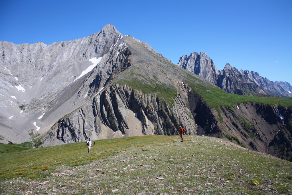
We started our trip with a group hike up Opal Ridge to Opal Peak. It was a fairly casual hike with the intention of getting to know each other. The trip up to the ridge was steep in some sections, but was on an obvious trail through alpine meadows and ledge systems and presented little difficulty. Upon gaining the ridge we took a lunch break and split into two groups, one continuing on to the summit and completing a traverse of the ridge exiting via Grizzly Creek and the other heading back the way we came. The walk along the ridge to the summit was beautiful and tons of fun, until we hit the meadows.

The views from the meadows surrounded by peaks, mountain sheep and lakes were amazing, the bushwhacking the ensued was not so pleasant. What we thought would be a pleasant stroll down some ridges, meadows and rolling trails back the car turned out to be an few hours of bushwhacking in and out of a gully to try to pick up the trail we were looking for.  We had a guidebook that clearly showed the descent route, so why couldn't we find it?!? after some struggling through the forest and hiking down some rubbly scree slopes, we finally got back to the car. Later that night we learned the trail we had been looking for had been decommissioned a few years back in favor of the Grizzly Bear habitat in that are. That explains it!!! Luckily the ridge was beautiful, making the journey worthwhile.


The next day Mike, Steve and I headed up the Wasootch River Valley to climb Wasootch tower, a pillar of rock set back at the end of the river valley and visible from the road and nearby Wasootch Slabs cragging area. The route is Grade II, 5.5 alpine rock with lots of loose choss to be aware of.  The hike in starts out pretty laid back, but quickly starts to gain elevation once you turn off into a second drainage.  part way up that drainage we scrambled up an embankment and started hiking/bushwacking up the lower, forested portion of the ridge. We quickly ate away at the elevation and broke out of the trees onto some slabby ledges where we scrambled up to the first vertical bit of climbing. Unfortunate, we had headed too far to the left and were at the wrong ridge as the topo clearly stated! So we backed down a bit, traversed an easy ledge system and once again scrambled to another vertical section.  This time we found a bolt and a piton that signified the start of our route.

The route than continued with a spicy little traverse and roof right of the get go followed bu a series of slabs, ramps, blocks and gullies and a lot of 3rd and 4th class scrambling sections.  Mike led the whole route and we pitched out the entire thing, but it would be possible to scramble without a rope in some areas depending on your comfort level. After the last pitch we scrambled across an exposed ridge that led us to a big meadow and a summit plateau and Cairne. We filled out the registry and had a well-deserved lunch break on the comfy summit, surround by peaks and great views of Barrier lake below. After lunch we did 2 rappels to reach a col and headed down an easy hiking trail back to the car.


On our 3rd day at camp we decided on a rest day, so we slept in and enjoyed a leisurely breakfast. After breakfast we climbed a few routes at Wasootch slabs before heading into Canmore for a swim and dinner at the pub. That evening we hung out at camp and put a group together to tackle our next days objective, Mt Indefitigable.


Mt Indefatigable  sits on the shores of Kananaskis lakes and has a beautifully striking line up the right side of it that just beacons to be climbed.  ever since I saw a photo of it in our guide book a couple years ago I have wanted to climb it. The route we did is called "Joy" and is 12 pitches long ranging from 5.4 to 5.8 along its length. It is a slab climb along side a long, sweeping corner which eats gear.


The slab is extremely featured, sometimes with crack systems, allowing for mostly fun and easy climbing. Mike, Steve and I along with Anita spent a magnificent 12 hour day working our way up the route in two parties of 2. We topped out at about 3pm pm and after a short scramble across a nicely exposed ridge and a few ledges we hiked down through endless alpine meadows back to the parking lot. It was an extraordinary day of beautiful views, good climbing and great camaraderie.


The following day, Wednesday, I decided that after a 12 hour adventure on Joy that I deserved a relaxed day out exploring.  The boys wanted to climb so they headed off up Mt Baldy with a small group and I took the car and went exploring.  I had a great day on my own! I treated myself to a fancy brunch at the Delta Hotel in Kananaskis village and then spent the remainder of my day hiking and taking photographs of the surrounding area.  I got some great close-ups of a deer that walked right up to me as well as spending some time watching the water bombers working away at controlling their prescribed burns in the area.

On our final day of camp we decided to keep things simple and headed back to Wasootch Slabs for a day of cragging.  We all had a great day of climbing and leading numerous routes in the area along with enjoying the sun and each others company. We ended the day with some excitment however. Mike, not wanting to be forgotten, decided to take the biggest whipper that any of us had ever seen.  He was at the very top of a 5.7 sport route and traversing on easy ground, about 20ft above his last bolt, when the hold he grabbed broke. It sent him for a 50ft fall once you factored in rope stretch and, me, his belayer, being lifted a good 6-8 ft off the ground. The rope caught him about 10ft from the deck.  It was a scary moment, but luckily, apart from a bruised ego and some scratches, everyone was ok. And with that, we decided our trip was done. We said our goodbyes and began our journey home.


It was a great trip. The ACC Prince George Section was a blast to hang out with. I would highly recommend the ACC summer camps to anyone who is looking to get outdoors and try their hand at some adventures.


Click Here for Full Photo Album


Wednesday, July 27, 2011

Dreamweaver


This past weekend Mike, Steve Oliver and I headed out to Marble Canyon (on Hwy 99, between Lillooet and Cache Creek) to climb Dreamweaver, a 10-pitch 5.8 trad route, up the mid wall. Dreamweaver starts at the base of the wall and climbs approximately 1100ft to the summit ridge of the cliff.  we spent the weekend out there with the intent of practicing our multi-pitch rock systems in hopes that we will be slightly more efficient during our upcoming week long trip to Kananaskis Country with the Prince George section of the ACC. Marble Canyon is a great place to practice for alpine climbing and climbing in the Rockies due to its undeveloped, adventurous & wild nature. Marble Canyon sees very little traffic so you have to be aware of loose rock and a little more diligent about route-finding and general preparedness than you do when you are climbing somewhere more popular such as Squamish. For example, we always carry extra gear and webbing on big routes in Marble Canyon in case the "s%?t hits the fan" and we need to back off a route part way up.


We spent the weekend camped out at a cool little provincial campground that sits right between Turquoise and Crown lakes. It always amazes me that this great campground and amazing climbing area are never busy; they seem to be just far enough off the beaten path to avoid the crowds. On Saturday morning we got up at 6am for a 7am start at the route.  We were unsure of the route-finding, approach and descent, so we wanted to leave ourselves lots of time.  It turned out that the approach was incredibly simple. It took us about 45 min to get from our camp site to the base of Dreamweaver, including the drive and hike/scramble in. The route finding on the climb turned out to be pretty straight forward as well, but that was largely due to the great topo that we had from Ken Cox of the Prince George Alpine Club. We spent a bit of time the night before thoroughly reading the topo and checking out the route ahead of time with binos, which I think helped out immensely in the long run.

The climbing itself was awesome; it had everything from easy face climbing, chimneys (of doom), crack systems, slabs and a bit of easy scrambling thrown into the mix for good measure.  A majority of the belays were on ledges & in moderately comfortable stances, making the experience all the more enjoyable.  There was one horrendous belay though that was in a cave that was dripping water and leaning right up against some prickly bushes, not so enjoyable! However, if you reach this point, keep in mind that with 60m ropes you can keep climbing to the top of the next pitch and skip this belay all together. All in all it took us about 8 1/2 hours to climb the route, including a lunch break on one of the many ledges.


Once we topped out onto the 3rd class section of the ridge and packed our gear away it was going on 5pm so we opted to skip the summit attempt and look for the descent gully. After about 10-15 min of scrambling around on the ridge we came to a huge gully with soaring limestone walls and a rap station attached to a tree. We headed down into the "Dreamweaver Gully" and began our trek back to the car.  The hike in the gully was surprisingly mellow. There was a lot of loose rock and debris to pick your way through, but it was no where near as steep as we were expecting.  It was also nicely shaded from the hot sun and even has a little stream running through it where you can refill your water bottles and enjoy a refreshing wash after a long climb.  It took us almost 2 hours to get back to the car from the top of the last pitch. All in all, it was a 12 hour trip tent to tent. A long day, but a great accomplishment!

The next day we were all tired from the long day before so we slept in a bit and had a leisurely breakfast before breaking down camp. We then headed up to the Apron (or Lower wall) area of Marble Canyon to climb a few more pitches before heading home. I led the first & second pitch of Sisyphus (linked together), which is a 5.8 mixed route.  It is mostly bolted, but run out on the second pitch, so a few key gear placements were preferable. The first pitch was great since it goes at 5.5 and is well bolted, but the second, 5.8 pitch was a bit of a challenge. 5.8 is basically my on-sight limit for sport climbing, so attempting a 5.8 mixed pitch while wearing a backpack was something else. After a fit of fear, frustration, and anger at the crux I pushed thru to the anchors without falling. I was terrified (and pissed at my partners for making me lead it) at the time, but looking back now, it was a pretty cool accomplishment and a bit of a climbing break-thru for me.  After that Mike lead a horrible traversing 4th/low5th section of Sisyphus up thru some rubbly ledges and to finish off our adventure, Steve found his limit leading the 3rd pitch, a 5.8 sickle on "Brown Sugar"; it was a great on-sight for Steve and an awesome accomplishment to push thru the fear factor and conquer that pitch. After that final pitch we all decided we were beat from the long day before, not to mention the rising temperature, so we rapped to the valley floor and headed out on our homeward journeys.

Overall, it was an awesome weekend of friendship, adventures, learning and testing our boundaries. Looking forward to more adventures in Kananaskis in the week to come!

Click here for full photo Album