On August 9-13, 2012, Mike and I headed
down to central Washington to attempt to climb the 14, 411ft high volcano, Mt.
Rainier. This would be the 3rd time we’ve traveled down to Rainier
for a summit attempt and the 4th time we’ve planned an attempt over
the past 4 years. The first go was with our friends Christian and Ursula Steidl
and Steve Oliver back in 2008. We made
it to about 13000 ft EL, just above the Disappointment Cleaver, before being
turned back due to incredibly cold, windy weather. The snow storm in the parking lot should have
been our first clue.....


We had plans with Steve Oliver to try again in 2010
but this time didn’t even make the drive down due to a bad weather
forecast. And just last month Mike and I
drove down to Rainier, with a mediocre weather forecast, but a possible
climbing window, to give it shot. We
were woken up in the middle of the night, while “camping” in the car at the
trail head, by a massive lightning and rain storm. When we got up in the
morning we registered for the climb hoping the weather would ease but after 4
hours of waiting for the rain to stop and learning that the lightning was
touching down at Camp Muir, we decided to call it off.


So last weekend, after anxiously watching
the forecast all week, we headed back to Mt Rainier with the promise of sunny
skies and low winds all weekend long. We
left after work on Thursday and arrived at our hotel in Eatonville at 9pm.
After a good sleep and tasty breakfast we drove an hour to the Paradise trail
head (5400ft EL) at Mt Rainier where we registered at the climbing center and
were on our way up to Muir Camp by 11am.
The hike up to Muir was slow and tedious. It took us about 2 hours of
winding our way up the “tourist” trails to reach the base of the Muir Snow
Field (about 7200 ft EL) and then another 3 hours of hiking up the snow field
to reach Camp Muir at 10,200 ft EL. Once we reached Camp Muir we dug out a tent
pad and set up our tent on the Cowlitz Glacier, melted some snow for drinking
water, make a yummy ravioli & Pesto dinner and had an early night to rest
up for our upcoming climb.
The next day we slept in until 8am and
after a leisurely breakfast we packed up our camp and moved up to a high camp
at Ingraham Flats. It took a little over
an hour to travel across the Cowlitz Glacier and up and through Cathedral Gap
to reach the Ingraham Glacier. We set up our high camp with a kick-ass
snow-kitchen and tent pad and spent the rest of the day sun tanning, reading
and relaxing in preparation for that night’s summit attempt.

After a few hours of sleep we awoke at
midnight to the sound of passing climbers. We crawled out of bed and watched
some shooting stars while we ate “breakfast” (can you call it that at
midnight?!?) and prepared for our climb.
We roped up and left the tent at 1:15 am for the journey up the
Disappointment Cleaver and the Ingraham Glacier. The excitement of the day started about 20min
out of camp when we reached out first crevasse that was about 1m in width a
required a pretty good jump to get across.
Shortly after the crevasse crossing we passed under the icefall and the
cliffs of the Disappointment Cleaver.

We
shortened up our rope and started the crux of the route, the steep ascent of
the rocks and steep snow on the Cleaver. It took us about an 1.5 - 2 hours to
reach the top of the Cleaver from our camp. After a quick snack break we lengthened
our ropes back into glacier formation and continued across the “flats” above
the Cleaver and began the steady climb to Mt Rainier’s Crater. We climbed
steadily up the snow slopes, with a few crevasse crossings and some traversing
to reach stable snow bridges along the way.
About 800 ft from the top the wind picked up and we were slowing down
due to the elevation so we bundled up in our puffy jackets for the final push
to the summit.

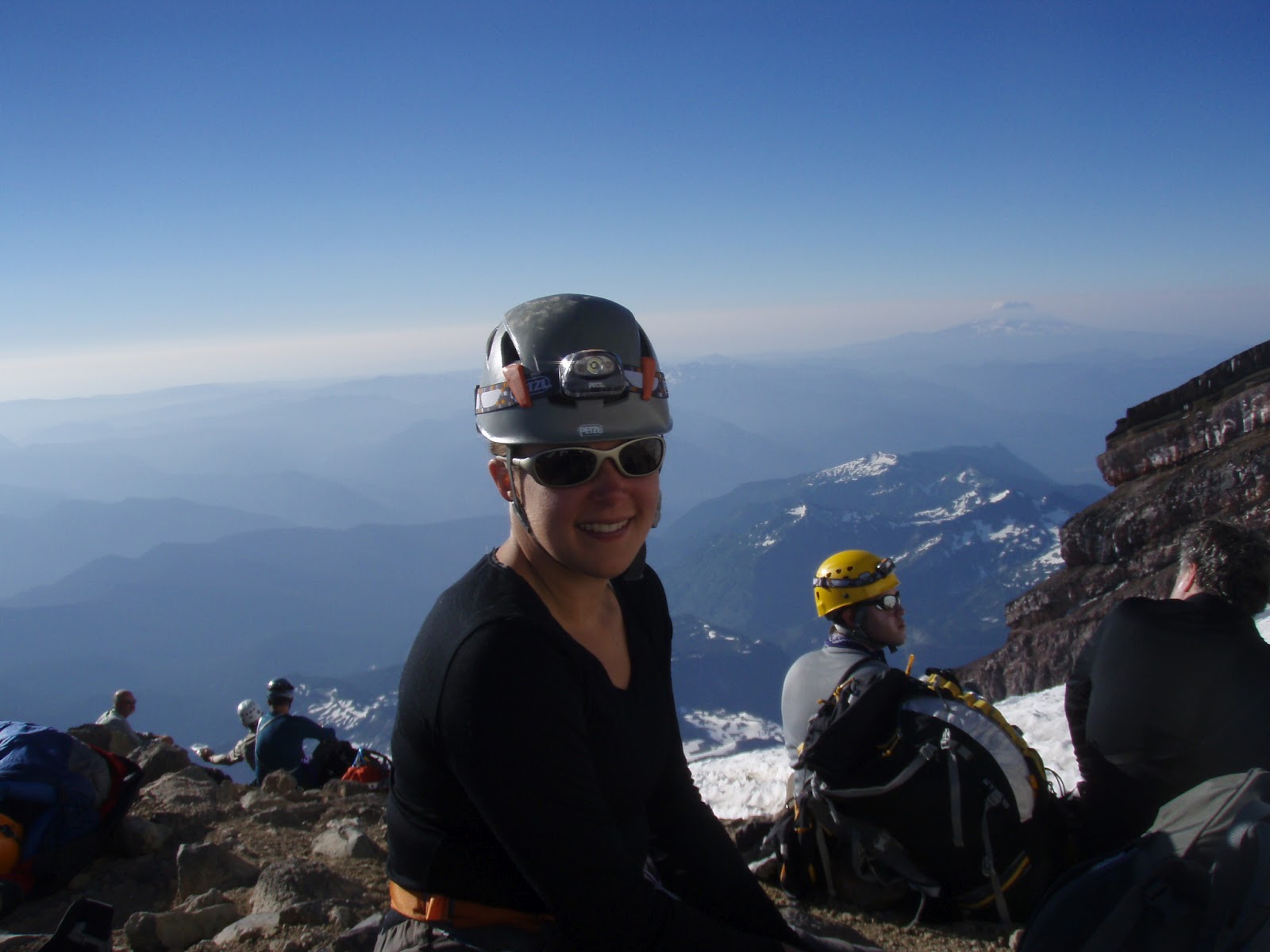
We reached the crater rim at about 5:15 am
with the first sign of light finally peaking over the horizon. The crater was a
great place for a break as it was sheltered from the wind. We crossed the crater in about 15min of flat
trudging, took a bit of a breather and then climbed the final 200ft to the true
summit; Columbia Crest. 14,411ft!
After
watching the sun rise for a few minutes and taking some summit photos, we
headed back into the crater to escape from the cold summit winds. It turned out
that out of the 100+ people climbing the mountain that day, we were only the
second party to reach the summit. It was quite something to have such a popular
summit all to ourselves! Once sheltered from the wind again we had some food
and water and signed the registry, which is stored about 100ft below the true
summit, and then prepared for the descent.

The descent was pretty straight forward. We
followed the same route back down as we had ascended. The entire route was
wanded and a majority of it was beaten trough in the snow. It was nice to see
the views of the surrounding peaks while descending since it was dark during
our entire ascent. The biggest challenge with the descent was trying to get
around all of the climbers who were still making their way up the mountain. We
arrived safely back at our camp at about 9:45am, making for a 4.5 hour ascent
and 3.5 hour descent, including all breaks other than time spent at the summit.

Once back at camp we spent a couple hours
having lunch and melting snow to rehydrate before breaking down camping and
continuing on down the mountain. We
descended into Camp Muir at about 12:30 pm where we packed up the rope and crampons, refilled our
water bottles (thanks to the friendly Hikers giving away water) and had a bit
of a breather. From there we began the
4800 ft long grind down the Muir snowfield, where some bum-sliding occurred,
and the tourist trails near Paradise, which were insanely busy. We finally
arrived back at the car at 6pm, Happy, but tired, 18 hours after the days
adventure began.
To wrap things up, here’s Mike’s Trip
Report:
From
Paradise take the Skyline trail following signs to Camp Muir. At around
7200 feet EL you will step onto the Muir Snowfield, this is usually the last
place to get running water so fill up. Once on the Muir Snowfield follow
the path, or compass bearings provided by the ranger station, towards Camp Muir.
Time of ascent from Paradise to Camp Muir is 5 hours with a full pack
covering 4800 feet EL.

Plan to spend a night at Camp Muir as this will
greatly aid in the acclimatization process and increase the odds of a
successful summit attempt. After spending the night at Camp Muir make
your way across the Cowlitz Glacier and through Cathedral Gap to Ingraham Flats
this covers 1000 feet EL and takes roughly an hour. Spend the rest of the
day enjoying the views and resting up at Ingraham Flats. Plan on leaving
Ingraham Flats by 1am if you wish to be ahead of the guide service. From
Ingraham follow the trail that will lead up for a few hundred feet before
dropping down slightly and going flat under some potential icefall hazard.

After this you will step onto the Disappointment Cleaver, at this point
shorten up the rope to minimize rock fall. Move quickly along the bottom
of the Cleaver to avoid potential rock fall. Follow the wanded ledges of the
Cleaver or, depending on the time of year, you may venture onto a steep snow
field (40-45 deg). After surmounting the Disappointment Cleaver extend
your rope back into glacier formation.

Again, follow the wanded trail
which will vary year to year to avoid the crevasses that plague the route.
As you ascend the mountain the overall steepness lessens until you
finally reach the crater rim where you will be rewarded with a 20 minute flat
walk across the inside to the crater before reaching the final 200 ft climb to
the summit. Don't be disappointed when you reach the summit if you cannot
find the register as is it located just above the crater floor on the trail to
the summit. Descend the same route, negotiating the many people still on
the way to the summit. Approximate travel times from Ingraham Flats are 4
1/2 hours for the ascent and 3 1/2 for the descent under good conditions.


.jpg)