Thursday, August 16, 2012

Mount Rainier 2012


On August 9-13, 2012, Mike and I headed down to central Washington to attempt to climb the 14, 411ft high volcano, Mt. Rainier. This would be the 3rd time we’ve traveled down to Rainier for a summit attempt and the 4th time we’ve planned an attempt over the past 4 years. The first go was with our friends Christian and Ursula Steidl and Steve Oliver back in 2008.  We made it to about 13000 ft EL, just above the Disappointment Cleaver, before being turned back due to incredibly cold, windy weather.  The snow storm in the parking lot should have been our first clue..... 


We had plans with Steve Oliver to try again in 2010 but this time didn’t even make the drive down due to a bad weather forecast.  And just last month Mike and I drove down to Rainier, with a mediocre weather forecast, but a possible climbing window, to give it shot.  We were woken up in the middle of the night, while “camping” in the car at the trail head, by a massive lightning and rain storm. When we got up in the morning we registered for the climb hoping the weather would ease but after 4 hours of waiting for the rain to stop and learning that the lightning was touching down at Camp Muir, we decided to call it off.


So last weekend, after anxiously watching the forecast all week, we headed back to Mt Rainier with the promise of sunny skies and low winds all weekend long.  We left after work on Thursday and arrived at our hotel in Eatonville at 9pm. After a good sleep and tasty breakfast we drove an hour to the Paradise trail head (5400ft EL) at Mt Rainier where we registered at the climbing center and were on our way up to Muir Camp by 11am.   

The hike up to Muir was slow and tedious. It took us about 2 hours of winding our way up the “tourist” trails to reach the base of the Muir Snow Field (about 7200 ft EL) and then another 3 hours of hiking up the snow field to reach Camp Muir at 10,200 ft EL. Once we reached Camp Muir we dug out a tent pad and set up our tent on the Cowlitz Glacier, melted some snow for drinking water, make a yummy ravioli & Pesto dinner and had an early night to rest up for our upcoming climb.

The next day we slept in until 8am and after a leisurely breakfast we packed up our camp and moved up to a high camp at Ingraham Flats.  It took a little over an hour to travel across the Cowlitz Glacier and up and through Cathedral Gap to reach the Ingraham Glacier. We set up our high camp with a kick-ass snow-kitchen and tent pad and spent the rest of the day sun tanning, reading and relaxing in preparation for that night’s summit attempt. 

After a few hours of sleep we awoke at midnight to the sound of passing climbers. We crawled out of bed and watched some shooting stars while we ate “breakfast” (can you call it that at midnight?!?) and prepared for our climb.  We roped up and left the tent at 1:15 am for the journey up the Disappointment Cleaver and the Ingraham Glacier.  The excitement of the day started about 20min out of camp when we reached out first crevasse that was about 1m in width a required a pretty good jump to get across.  Shortly after the crevasse crossing we passed under the icefall and the cliffs of the Disappointment Cleaver.  

 We shortened up our rope and started the crux of the route, the steep ascent of the rocks and steep snow on the Cleaver. It took us about an 1.5 - 2 hours to reach the top of the Cleaver from our camp. After a quick snack break we lengthened our ropes back into glacier formation and continued across the “flats” above the Cleaver and began the steady climb to Mt Rainier’s Crater. We climbed steadily up the snow slopes, with a few crevasse crossings and some traversing to reach stable snow bridges along the way.  About 800 ft from the top the wind picked up and we were slowing down due to the elevation so we bundled up in our puffy jackets for the final push to the summit. 

We reached the crater rim at about 5:15 am with the first sign of light finally peaking over the horizon. The crater was a great place for a break as it was sheltered from the wind.  We crossed the crater in about 15min of flat trudging, took a bit of a breather and then climbed the final 200ft to the true summit; Columbia Crest. 14,411ft! 


After watching the sun rise for a few minutes and taking some summit photos, we headed back into the crater to escape from the cold summit winds. It turned out that out of the 100+ people climbing the mountain that day, we were only the second party to reach the summit. It was quite something to have such a popular summit all to ourselves! Once sheltered from the wind again we had some food and water and signed the registry, which is stored about 100ft below the true summit, and then prepared for the descent.
 
The descent was pretty straight forward. We followed the same route back down as we had ascended. The entire route was wanded and a majority of it was beaten trough in the snow. It was nice to see the views of the surrounding peaks while descending since it was dark during our entire ascent. The biggest challenge with the descent was trying to get around all of the climbers who were still making their way up the mountain. We arrived safely back at our camp at about 9:45am, making for a 4.5 hour ascent and 3.5 hour descent, including all breaks other than time spent at the summit.

Once back at camp we spent a couple hours having lunch and melting snow to rehydrate before breaking down camping and continuing on down the mountain.  We descended into Camp Muir at about 12:30 pm where we  packed up the rope and crampons, refilled our water bottles (thanks to the friendly Hikers giving away water) and had a bit of a breather.  From there we began the 4800 ft long grind down the Muir snowfield, where some bum-sliding occurred, and the tourist trails near Paradise, which were insanely busy. We finally arrived back at the car at 6pm, Happy, but tired, 18 hours after the days adventure began.
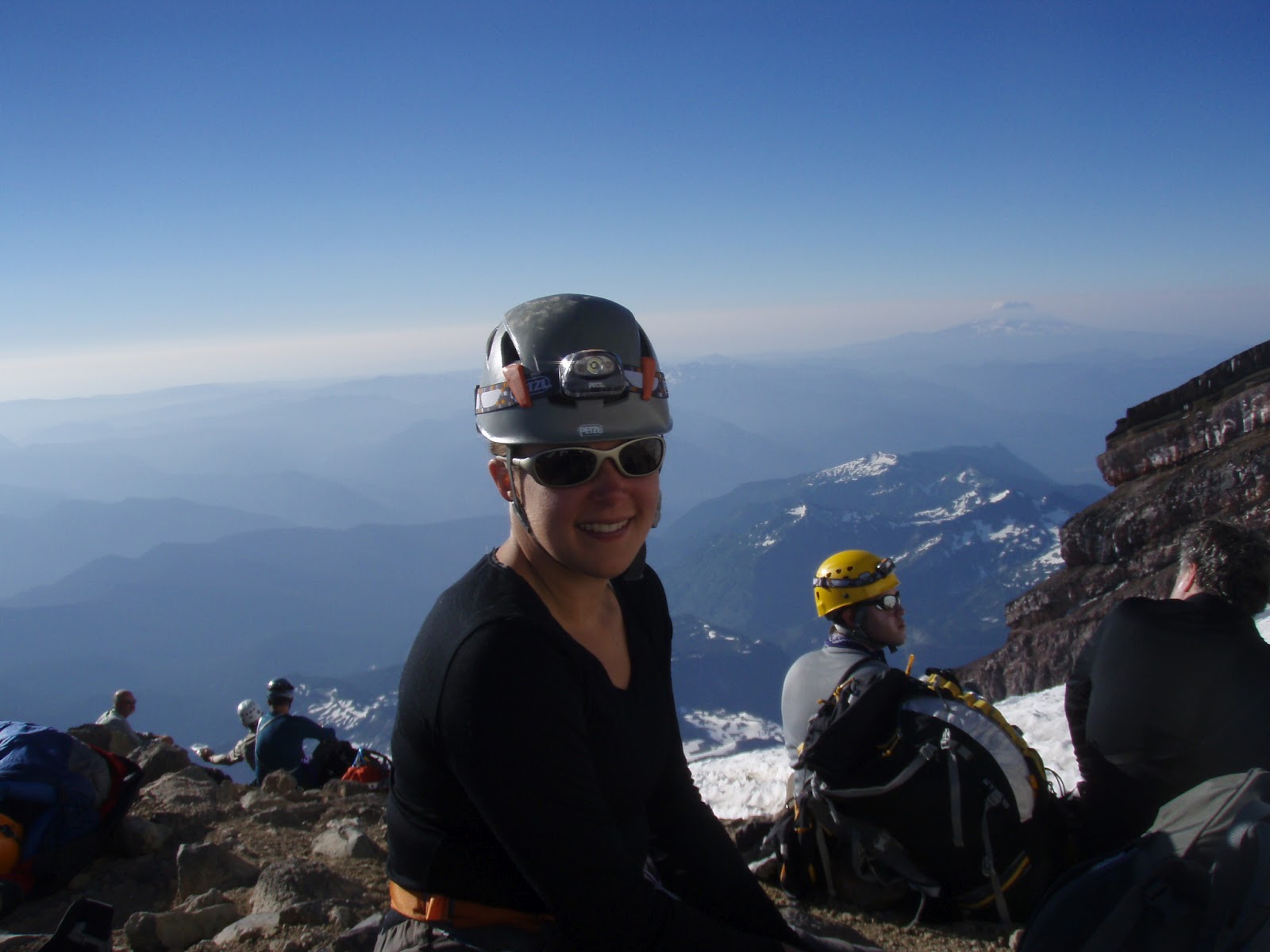

To wrap things up, here’s Mike’s Trip Report:

From Paradise take the Skyline trail following signs to Camp Muir.  At around 7200 feet EL you will step onto the Muir Snowfield, this is usually the last place to get running water so fill up.  Once on the Muir Snowfield follow the path, or compass bearings provided by the ranger station, towards Camp Muir.  Time of ascent from Paradise to Camp Muir is 5 hours with a full pack covering 4800 feet EL.  


Plan to spend a night at Camp Muir as this will greatly aid in the acclimatization process and increase the odds of a successful summit attempt.  After spending the night at Camp Muir make your way across the Cowlitz Glacier and through Cathedral Gap to Ingraham Flats this covers 1000 feet EL and takes roughly an hour.  Spend the rest of the day enjoying the views and resting up at Ingraham Flats.  Plan on leaving Ingraham Flats by 1am if you wish to be ahead of the guide service.  From Ingraham follow the trail that will lead up for a few hundred feet before dropping down slightly and going flat under some potential icefall hazard.


  After this you will step onto the Disappointment Cleaver, at this point shorten up the rope to minimize rock fall.  Move quickly along the bottom of the Cleaver to avoid potential rock fall. Follow the wanded ledges of the Cleaver or, depending on the time of year, you may venture onto a steep snow field (40-45 deg).  After surmounting the Disappointment Cleaver extend your rope back into glacier formation.  

Again, follow the wanded trail which will vary year to year to avoid the crevasses that plague the route.  As you ascend the mountain the overall steepness lessens until you finally reach the crater rim where you will be rewarded with a 20 minute flat walk across the inside to the crater before reaching the final 200 ft climb to the summit.  Don't be disappointed when you reach the summit if you cannot find the register as is it located just above the crater floor on the trail to the summit.  Descend the same route, negotiating the many people still on the way to the summit.  Approximate travel times from Ingraham Flats are 4 1/2 hours for the ascent and 3 1/2 for the descent under good conditions.

Thursday, August 9, 2012

3 Peak Challenge: Kayaking & Climbing


On July 28-29 my running buddy Banafsheh and I joined Bowen Island Sea Kayaking for their "3 Peak Challenge" tour. The tour was a two day, one night trip that included paddling to 3 Howe Sound islands, Anvil, Bowen and Gambier, and climbing the highest peak of each, complete with with a campout on Gambier Island. The three peaks that were climbed were Mount Gardner on Bowen Island (727m), Leading Peak on Anvil Island (765m) and Mt Artaban on Gambier Island (615m). On Saturday night we camped on Gambier Island at Halkett Bay. The tour was an excellent way to get a taste of sea kayaking in the Howe Sound while breaking up the paddle with some hiking. The days were long (10-12 hours of activity) which made for a bit of an endurance test, but in a fun and challenging way.


We started our adventure at 6am on Saturday morning with a drive to Horseshoe Bay to catch the 7am ferry over to Bowen Island. After a quick, 20min sail we walked down to the  Bowen Island Sea Kayaking shop to meet our guide, Lisa and our two other kayaking buddies, Peter and Lisa. All three of them were residents of Bowen Island. We spent the next 90 min or so organizing our gear, driving over to our launch point and packing our boats. At exactlty 9am we were off!

We started with a 16km paddle to Anvil Island. We lucked out and had the current and wind heading in our direction. Combined with calm waters, we had a very quick and uneventful 2 hour paddle to reach Pebbly Beach at Anvil Island.  The paddle was beautiful and interesting as we passed sea lions and various sea birds plus enjoying great views of the Howe Sound islands from the water.There was one are near a bird sanctuary where we stopped and watched the sea lions surround and show off their swimming skills. very cool!

Once we reached Anvil Island we beached our boats and got organized for our first hike, Leading Peak, which is the highest peak in Howe Sound. The hike was about 10km round trip with 765m of elevation gain and took us about 2.5 hours up and 2 hours back down.  The hike was quite steep most of the time, but had some areas of reprieve.  It was a fun trail with a bunch of little scrambling sections along the way and some nice scenery of Howe Sounds, a small lake and an impressive viewpoint where you first get a glimpse of the steep and pointy summit tower. The summit tower looks quite daunting, and although it is a steep hike the trail does a good job of switch backing and winding its way up some ledge systems to avoid any serious scrambling. On the Summit of Anvil you are rewarded with 360 degree views of Howe Sound and nice a wooden "patio" (aka Heli pad) to have a snack and sun tan. On a nice day you can see from  the Lions all the way to Black Tusk. It's absolutely stunning!


Once we got back to Pebbly Beach we rested for a few minutes and then packed our boats to head out to Gambier Island.  While we had been hiking the tide came in and unfortunately for us, the beach that we landed on was basically submerged.  We managed to fight the waves and launch our boats with minimal beach space, but not without getting a good soaking in the process. Luckily it was hot out!


The next segment of the trip took us about 2 hours to paddle about 10 km from Anvil Island to Halkett Bay on Gambier Island. We were fighting the waves and wind this time and it made for some challenging paddling. Along the way we say eagles and some tiny baby sea lions that were awfully cute! Once we got to Halkett Bay we staked out a camp site and enjoyed an Ocean side dinner of pasta and salad, complete with wine and cookies for dessert.

The next day we got up at 7 am to tackle our 2nd hike of the trip.  After a leisurely breakfast of oatmeal, fruit, yogurt and coffee we headed up Mt Artaban.  The hike was significantly less steep than leading peak with some nice meandering sections mixed into the climbs.  The hike took us about 2 hours to get to the 615m high summit where we enjoyed the views of Howe Sound and had a snack. The full hike took about 3.5 hours round trip and covered approximately 10km through some scenic creek beds, along rock walls and along some soft, mossy trails.


After a quick lunch back at Halkett Bay, we broke down camp, packed our kayaks and headed Gardner Landing on Bowen Island. The Paddle was about 10km long but took us a little over two hours due to high winds and "washing machine" like wave conditions which made the paddle someway slow and challenging.
Once we reached Bowen Island, Martin from the Kayak shop picked up our boats and we said goodbye to the kayaks, completing the paddling portion of the trip. Only one more Peak to go to complete the challenge! Lisa and Peter had said goodbye to us at Halkett Bay and opted to paddle home so it was just Lisa, Ban and I for the trek up Mt Gardner. We decided to rock it off in a speedy fashion, so we left all extra gear (i.e. weight) with Martin and headed out for a light and fast trip to the top of 727 m high summit.  It took us about 1hour and 15min to cover 6 km to the summit with steady climbing the entire way. Think "Bowen Islands Grouse Grind".  We reached the top just before 5pm and opted to relax and take in the view of the Lower Mainland and Howe Sound for a while before heading back to Snug Cove. The to Snug Cove took us about 1 1/2 hours from the summit and covered about 10km of trail.


36 hours later and our challenge was complete! We collected our gear, said our goodbyes to Lisa and after a tasty burger at the pub we boarded the 8pm ferry to Horseshoe Bay to begin our journey home.

Click Here for the full Photo Album


Sunday, July 22, 2012

Knee Knacker 2012


On Saturday I took part in the 24th (my 4th) running of the Knee Knackering North Shore Trail Run, a 30mile race along the Baden Powell trail from Horseshoe Bay to Deep Cove, travelling up, over and around the North Shore Mountains.


I was a bit nervous going into the race as it had been 3 years since I last ran it. I had been committed to the long weekend runs throughout my training, but didn't get out to cover as much mileage as I would have liked during the week. I was also a bit concerned that I had trained in the cool spring weather and now and race day we would be in the middle of a heat wave with high humidity.


As we arrived at the start line at 5am on Saturday morning, the nerves changed to excitement and before I knew it, we were off! The first 45 min of the race or so was exciting but a bit painful trying to warm up and find my pace.  After about an hour or so though, I had settled into a comfortable pace that was stiff but sustainable while climbing up Black Mountain.


Part way up Black I decided to hang back for a few seconds to chat with Lara and found out that she was really not feeling well.  She sent me on my way preferring to travel at her own pace, and so for the first time ever, I was on my own for a Knee Knacker race! I must admit that I missed having my partner in crime around during the race. Although it was sometimes nice to be able to run my own race and follow exactly what my body wanted/needed me to do, I missed the company  and the encouragement to get me through the tough patches. I definitely had a dig a bit deeper than ever before to keep pushing through at times.


But, back to the race..... I was surprised at how good I felt climbing Black Mountain and was shocked to fell like I still had a ton of energy left in the tank when I hit the first aid station; I'm usually dying for some downhill by then. The view at the top of Black was extraordinary this week, making the hard work well worth it! It took me 2:30 hour to get to Cypress Bowl, the 1/4 mark and the first check point. I was happy to have a 30min buffer on the cut-off time. 

The second 1/4 was interesting for me.  We hadn't trained on the Hollyburn portion of the route at all this year, so it had been 3 years since I'd last run on this portion of trail and I was completely alone as I navigated the trails, creeks and mud pits. It was a bit unnerving at times, not being completely confident of the route up there, but it felt good to make it through without any mishaps. I was happy to arrive at Hollyburn Lodge and had a great time cruising down the descent to the 1/2 way check point at Cleveland Dam.  That long descent felt excellent, and although I know I have some work to do on my downhill running skills, it felt fun and a lot more effortless than normal. 

Coming into the 1/2 aid station was great fun. I loved having a few minutes for hugs and encouragement from my friends and family on route and at the check point.  I was sad for Lara when I learned that she had dropped at Cypress and I saw her at the check point, but unfortunately sometimes its not meant to be and its best to listen to your body and do what needs to be done. 

After a change of shirts and socks and a boost from everyone's encouragement, I headed up Nancy Green way towards Grouse Mountain.  The section up Grouse to St George's Bench as hot and humid and I was more that thankful to have a bag full of ice in tow to cool off with. I was also a bit discouraged in the race and difficulties to come when I learned that Lisa had also dropped and then ran into other running buddies who were having a bit of a rough time. 

I had left the 1/2 way check point right on track for a 9:00hr finishing time, which would be a personal best for me, but I wasn't convinced at that point that I would be able to sustain that pace for another 25km. When   I hit Mountain Highway at just around 6:15  in and then the 3/4 check point at 6:45, still on track for a 9hr finish, I was shocked and excited.  I only had to hold it together for another 12km! and, Id never felt so good at this point in the race in the past.  


That section, as usually, felt like a bit of struggle; never quite being able to find a decent rhythm. But it was still an improvement over previous years as there was no cramping or nauseousness, and I ran significantly more than I normally do in that portion of trail.  It felt good to feel strong in a race for a change and to push a bit harder without crashing and burning (yet). After making it past the bench in one piece my confidence in being able to do this race on my own  and hopefully finishing strong was growing.  


Unfortunately, this is where things changed. As I descended into the "bog" at Lynn canyon park I could feel the heat and humidity increasing and it was getting to me.  I did alright cruising through the bog, but the climb out to Lillooet road did me in.  I hit a wall was just dragging myself along the trail. It took everything I had to keep running, and running was only a consideration on downhills and sometimes flats at this point. If it weren't for the encouragement and cold sponges from the aid stations and  the company of Michael, the tasty Espresso Gel he gave me and the distraction from the suffering as we chatted and played leap frog through  the last 10km of the race, it would have been a rough couple of hours. 


The friendliness, encouragement and camaraderie of the volunteers and fellow racers is what keeps me coming back to this race.  hike up the Seymour grind was a battle and took everything I had, mentally and physically, to get to the top. Knowing that it was my last big hill and that I had 5km of downhill coming my way helped motivate me to keep on pushing. When I hugged the post at the top of the grind (can't mess with tradition!), I was 8hrs 10min into the race and my hopes of a 9hr race and a PB faded. At that point all I wanted to do was finish, my time didn't really matter anymore.


I struggled with some cramping and fatigue as I descended towards the old buck trail, but luckily for me as I pushed on my legs decided they were enjoying the downhill and with some coke, ice and snacks at the Seymour aid station I found the hit of energy I needed to step it up for a strong finish. Although I was tired, I was still feeling surprisingly good for being 45km into the race.


I cruised my favorite section from Seymour road to Indian River Road and then, even with a bit of battling on the uphill sections after the "7 Bridges of Hell, I ran the last couple kilometers into Deep Cove with more speed and energy than I have ever felt before in this section of race. It was actually even fun! As I descended the final stairs into Deep Cove I looked at my watch and it was just seconds over 9hrs, I was stoked! I was about to get a Personal Best! I cruised down the sidewalk and crossed the finish line at 9:02:00, 9min 57sec faster than my previous best from 2006. Yay! I couldn't be happier with the outcome.


Overall I had a great day and even with the struggles, it was the best I have ever felt on the race and I can't wait to do it again in a couple years. A big thank you to my friends, family, run/training buddies, volunteers and race committee for all being part of making this a great event!


Final Results:


Final Place: 156  
Place in Gender: 48/62  F  
Place in age Group: 26/33  F-39     
Finish time: 9:02:00 
         
First 1/4  Place, time, pace:               186 2:29:37 19:57  
Second 1/4 Place, time, pace:               173 1:59:26 16:22  
First 1/4 + Second 1/4 Place, time:         179 4:29:03
Third 1/4 Place, time, pace:                148 2:15:56 18:23  
1st 1/4 + 2nd 1/4 + 3rd 1/4 Place, time     167 6:44:59  
Fourth 1/4 Place, time, pace:               127 2:17:02 17:35  
Final Place:                                156 9:02:00 


A few facts from the KK website:


  • 212 starters is a record, beating previous high of 209 in 2007
  • 189 finishers
  • 89.2% finish rate is 2nd lowest ever; lowest is 86.4% in 1991, and this is only the 2nd time ever below 90%
  • 92 first-time finishers out of the 189 — almost half, which is about par for the course
  • only 20 Personal Bests, which is much below normal
  • median time was 7:44:46, which is 2nd slowest ever — only beaten by 7:47:00 in 1999 (year of the biggest, baddest snow)
  • no records set in any of the age groups


Click Here for Race Pics


Monday, July 9, 2012

Summer!


Its been a while since I've posted so I thought I'd write a quick note about what I've been up to recently.


We're down to the wire now Knee Knacker! only 5 more days till race day! yikes! I spent every weekend in June  training for the race and had a great time building up the mileage with  great group of gals keeping me company. Of course there were the expected challenges along the way with unplanned "detours", crazy rain and snow, and the expected tired legs after many hours on the trails. But, with all that being said, the training felt good and went quite well this year. 


Other than running I've been trying to get in a bit of climbing. We've been out to Squamish a couple of times, both days in he Smoke Bluffs where we checked out some new-to-us areas, such as Lumberland. We also went out to a sport climbing area called Exit 38, which is just off the I-90 about 40min east of Seattle.  Exit 38 is great fun with an excellent variety of easily accessible routes. 


Finally, this seems to be a popular summer for weddings! Mike and I joined Mark and Dyan for a nice evening at the Brock House in Spanish Banks to partake in the tasting for their wedding reception. It was a fun night of good company, tasty food and beautiful setting.


And, just this past weekend we attended the wedding of our friend Luke Witte to his new bride Kayleigh.  It was a beautiful outdoor ceremony and reception and it was a blast dancing, catching up with friends and enjoying the BBQ dinner and candy buffet!